| |

Home
Rails and
Trails
Historic
Trails
Rail History of
Central
Alberta
Rail
Heritage
Preservation
High Speed
Rail
Corridor
for
Alberta
The Trans
Canada
Trail in
Central Alberta
Innovative
Transport
Sustainable
Community
Heritage
Regional
Rail History
Red Deer
and Area
Personal
Profile
Contact Me
Links
Site Map
|
The Calgary and Edmonton Trail (C & E Trail)
What eventually became known as the
Calgary and Edmonton Trail was developed around an ancient natural
pathway that followed a glacial corridor on the western margin of
parkland located between the dense forest to the west and the hilly land
to the east.
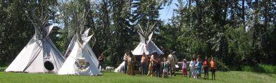
The pathway, along with the rivers and their many tributaries, was used
by aboriginal people in the area and the early explorers and fur
traders. In 1800, David Thompson referred to the northern portion of the
pathway as the Wolf's Track.
Other names that have been used for portions of the trail include the
Bow River Trail, the Fort Benton Trail, Old North Trail, Overland Trail,
Morley Trail, Cree Trail and the Middle Black Foot Trail.
In 1873, the Methodist missionary John McDougall, his brother David,
and his father George, blazed a crude 450-km cart road from Fort Edmonton
(originally established in 1795) south to the Peace Hills near present
day Wetaskiwin, past the Bear Hills near Hobbema, over the Red Deer
River to Lone Pine south of Bowden and southwest to a mission at Morley,
about 80 kilometres upstream on the Bow River west of present day
Calgary. This 'built' trail was briefly referred to as the Morley or
McDougall Trail with the portion between Lone Pine and Morley retaining
the name much longer.
The trail crossed the Red Deer River at a natural and relatively safe
ford about six kilometres upstream from the current city of Red Deer
where Fort Normandeau is located.
In 1875, the North West Mounted Police established Fort Calgary and they
carved out a wagon trail from there to Lone Pine to join up with
McDougalls' trail north to Fort Edmonton. At that time there were no
recorded inhabitants other than aboriginals between Calgary and Edmonton
although hunter and trapper Addison McPherson had reportedly built a log
cabin at the Red Deer River Crossing in 1872.
This new trail
became known as the Edmonton-Calgary Trail and was part of the commercial
fur trade and whiskey trail from Fort Benton in Montana, the head of
navigation on the Missouri, linking Fort Benton, Fort Whoop-Up (Lethbridge)
established in 1869, Fort Macleod, Fort Calgary and Fort Edmonton.
In 1882, a number of former freighters, land surveryors and other
pioneers took up claims, mostly on the south side of the Red Deer River, between the ford,
referred to as 'the Crossing', and Waskasoo Creek, where the current
city of Red Deer was established years later.
Early settlers at 'the Crossing' included John T. Moore, Jack Little,
William Kemp, George and Jim Beatty, 'Addy' McPherson and Robert
McClellan. The Saskatchewan Land and Homestead Company was granted 180
alternating sections of land around the Crossing.
More settlers were attracted to the Crossing in 1883. The McKenzies built a sawmill, G.C. King a store and M.P.
Collins a stopping house. Ed Barnett was the first settler between the Red Deer River and Fort Edmonton
locating at what was to become Lacombe.
 The arrival of the
Canadian Pacific Railway in Calgary in 1883 meant a dramatic increase
in traffic going north along the Calgary and Edmonton Trail. The first regular mail
service along this route was established in July of 1883. John Coleman and Addy Macpherson had obtained the contract to carry the
mail bi-weekly along with some light freight, as well as passengers.
A month later, Donald McLeod established the first stage service. The
fair each way was 25 dollars, a considerable amount of money at the
time, allowing a hundred pounds of luggage. The arrival of the
Canadian Pacific Railway in Calgary in 1883 meant a dramatic increase
in traffic going north along the Calgary and Edmonton Trail. The first regular mail
service along this route was established in July of 1883. John Coleman and Addy Macpherson had obtained the contract to carry the
mail bi-weekly along with some light freight, as well as passengers.
A month later, Donald McLeod established the first stage service. The
fair each way was 25 dollars, a considerable amount of money at the
time, allowing a hundred pounds of luggage.
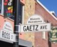
In 1884, Rev. Leonard Gaetz moved his family from Ontario to the
abandoned Jack Little claim near Waskasoo Creek. He bought the store at
the Crossing from G.C. King and became the land agent for the
Saskatchewan Land and Homestead Company. The Crossing townsite was
surveyed as Deerford but never developed. Sage Bannerman started a ferry
operation at the Crossing, purchasing McPherson's claim.
As traffic increased along the trail, stopping houses where travellers
as well as freight and stagecoach crews could receive food and shelter,
horses rest and settlers temporary housing, were
established at least every 20 miles between Edmonton and Calgary.
 Stopping houses
included McClellan's at Red Deer Crossing, Lone Pine (east of Bowden),
Content's at Poplar Grove (now Innisfail),
'The Spruces' north of Poplar Grove, Cache Camp (west of Penhold),
Blindman Crossing (south of Blackfalds), Barnett's (Lacombe) and
Barker's (Ponoka). Stopping houses
included McClellan's at Red Deer Crossing, Lone Pine (east of Bowden),
Content's at Poplar Grove (now Innisfail),
'The Spruces' north of Poplar Grove, Cache Camp (west of Penhold),
Blindman Crossing (south of Blackfalds), Barnett's (Lacombe) and
Barker's (Ponoka).
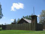
In 1885, as a result of the Riel Rebellion, the Alberta Field Force
moved soldiers and police from Calgary to Edmonton. Lieut. Normandeau
and 20 men stayed at Red Deer Crossing to guard the trail and river,
commandeering the
stopping house and building a fort around it (now known as historic Fort
Normandeau). At the same time, Fort Ostell was built at the Battle River (at present-day Ponoka).
In 1886, the North West Mounted Police set up a detachment at the fort.
The following year, the first log school house was built and the Alberta
Lumber Company built a mill on the Red Deer River near Innisfail.
 By 1888, travellers
along the Calgary-Edmonton Trail could choose from four different types
of vehicles, from freighter wagons to closed light stagecoaches.
A trip on a freighter wagon took almost two weeks. The stagecoach was
much faster at four to five days. By 1888, travellers
along the Calgary-Edmonton Trail could choose from four different types
of vehicles, from freighter wagons to closed light stagecoaches.
A trip on a freighter wagon took almost two weeks. The stagecoach was
much faster at four to five days.
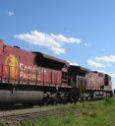
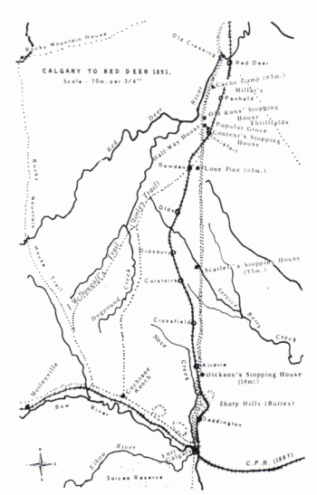
The role of the trail took a
dramatic turn when the Calgary and Edmonton Railway was constructed in
1890-91. Although the overall route of the railway was to follow the
general C & E Trail corridor, the railway
decided on its own route to reduce the grade of the railway or to
accommodate preferred locations for communities. North of Poplar Grove
(renamed Innisfail) to south Red Deer, the railway was built a couple of
miles east of the C & E Trail.
The settlement at Red Deer Crossing generally expected that the railway would cross the river at
that settlement. In fact, a townsite had been laid out in anticipation
of the railway going through there.
However, as a result of a deal made with Rev. Leonard Gaetz,
the Red Deer townsite and railway crossing of the river was located a
few kilometres downstream, resulting in the settlers at the Crossing
moving to the
new location.
Once the rail line was completed to South Edmonton in 1891, travel between
the two major cities was reduced to 12 hours from 4 days by stagecoach
marking the end of the Calgary-Edmonton Trail service.
During the 1890s, a new road was built to link the towns the railway built or went through. This new road
eventually became Highway 1 in the 1930s and renamed Highway 2 when the
Trans Canada Highway was being built as an east-west highway in the 1950s.
It later became Highway 2A when the newer four lane Highway 2 was built in the late
1950s to early 1960s.
The new Highway 2 expressway was built over some portions of the old C &
E Trail. Most portions of the Calgary & Edmonton Trail still exist as
country roads.
An ancient natural trail has evolved to become one the most dynamic
economic corridors in North America.
The Calgary and Edmonton Railway
(detailed)
Progress on the
Completion of the Trans Canada Trail in Central Alberta
 |
|
|